Tropical Depression Nine to Bring Fringe Impacts this Sunday – WSVN 7News | Miami News, Weather, Sports
We continue to track Tropical Depression Nine, which formed Saturday morning between the Bahamas and Cuba over the southwest Atlantic Ocean. While the center of this system is forecast to remain offshore from South Florida, it will be close enough to bring us some fringe impacts.
The center of this system will track northward across the Bahamas Sunday into Monday while intensifying into a tropical storm, getting the name, Imelda.
While this happens, we’ll get rounds of passing, gusty downpours throughout the day Sunday. It’s impossible to time out when these showers are most likely so prepare for the anytime risk of showers and thunderstorms this Sunday.
Otherwise, skies will gradually turn more cloudy with high temperatures very seasonable into the upper 80s.
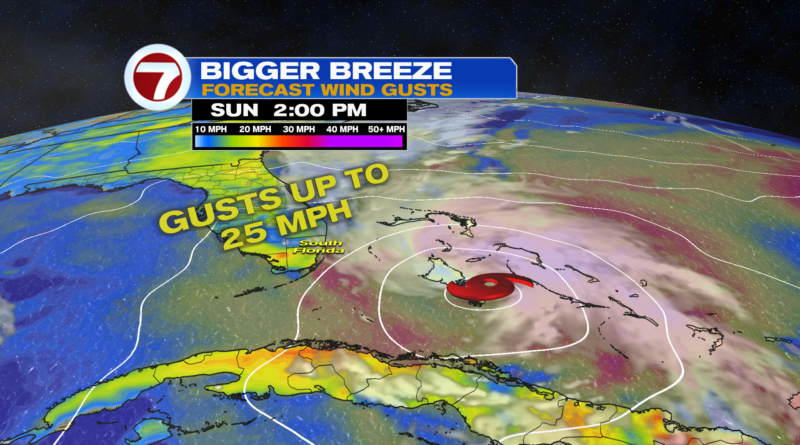
In addition to the times of showers this Sunday, it will also be quite breezy. Sustained winds will reach 10-20 mph with gusts up to 25 mph for most locations.
This will make for hazardous marine conditions with a Tropical Storm Watch in effect for Biscayne Bay and our coastal waters. A Tropical Storm Warning is in effect for the coastal waters to our north and farther offshore toward the Bahamas.
While conditions will start to turn drier overnight tonight as the tropical system pulls to the north, the breezy conditions will linger through the start of next week. It will flip to a northwest/west wind opposed to today’s north/northeast wind. Peak wind gusts Monday into at least Tuesday will generally reach 25-30 mph.
This drier weather trend will persist through Wednesday before an incoming front could stall out across the area late-week and into the weekend, leading to a rise in rain chances once again. This is an uncertain forecast, however, as it will depend on where this front actually stalls out.
Tropical update
There are currently two active systems in the Atlantic basin: Tropical Depression Nine and Hurricane Humberto.
Tropical Depression Nine is forecast to become a tropical storm as it travels across parts of the Bahamas today into Monday. By Tuesday, it is forecast to turn more toward the east while intensifying into a Category 1 hurricane while distant Hurricane Humberto helps pull it away from the US.
With that said, tropical-storm-force winds will be possible along parts of the east coast of Florida Monday into Tuesday while the strongest of the winds remain offshore.
Beyond then, the most likely path is for future-Imelda to continue to track east and farther away from the US. Rain and marine impacts will be the main concerns for parts of the Southeast early to mid week despite it unlikely to make landfall.
The other system out there is Hurricane Humberto. It is forecast to remain a major hurricane over the open waters through Tuesday before curving toward the northeast. It could pass close to Bermuda midweek, and it is not a concern to the US.