Strong nor’easter forces water rescues and inundates roads as it moves up the East Coast – WSVN 7News | Miami News, Weather, Sports
(CNN) — An impactful nor’easter is unleashing damaging wind gusts, heavy rain and coastal flooding as it tracks up the mid-Atlantic coast.
The storm is packing a serious punch as it slowly moves north and disrupts air travel at major Northeast airports and threatens to push the ocean into homes and onto roads along the mid-Atlantic coast multiple times through Monday.
This coastal storm is called a nor’easter due to the prevailing wind direction from the northeast ahead of its center. These northeast winds push water toward the coast, causing it to erode beaches and pile up and cause flooding.
Here’s the latest:
- Water rescues: Authorities in Georgetown, South Carolina, rescued several motorists trapped Sunday morning by floodwaters after nearly 10 inches of rain fell there in 24 hours Saturday into Sunday, Georgetown County Emergency Services Director Brandon Ellis told CNN. No one was injured. Numerous people in Columbus County, North Carolina, were also rescued from vehicles stalled across flooded roadways, according to local officials.
- Punishing winds: Wind gusts over 50 mph have been observed in North Carolina, Virginia, Maryland, Delaware and New Jersey as of Sunday afternoon. A gust of 61 mph was measured at North Carolina’s Cape Lookout while gusts for New Jersey’s Sea Isle City spiked to 59 mph. Strong wind gusts will continue to spread north.
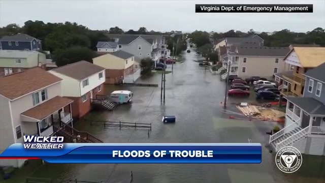
- Dangerous coastal flooding: Water levels reached hazardous heights in multiple states during Sunday afternoon’s high tide. Parts of coastal Virginia hit major flood stage, the most severe level, Sunday afternoon and dozens of other locales in the mid-Atlantic experienced moderate flooding. Monday’s high tides will bring renewed rounds of flooding in some of the same areas and points north. Some locations could see water levels reach a mark not touched in more than a decade.
- Travel woes: The storm is affecting air travel in the Northeast, with ground delays due to weather remaining in place Sunday night at Boston Logan and John F. Kennedy airports, according to the Federal Aviation Administration, after ground delays at Reagan National, Newark Liberty, Philadelphia and John F. Kennedy were cleared earlier in the day. Average delays at JFK were more than three hours late Sunday, the agency reported. As of 9:30 p.m. ET Sunday, nearly 7,000 flights within, into or out of the US were delayed, according to flight tracking website FlightAware.com.
Days of significant coastal flooding
The slow movement of the nor’easter will result in multiple rounds of coastal flooding that could could inundate roads and homes and increase the beach erosion potential up and down the East Coast.
Dozens of river gauge locations are expected to reach moderate or major flood stage, the most severe level, from this nor’easter through Monday. Areas from the Virginia Tidewater into Delaware and southern New Jersey are of particular concern.
Water levels climbed into minor flood stage on Sunday afternoon in Atlantic City, New Jersey, and shut down Route 40 and Route 30 in both directions in and out of the city. The flood threat will climb even higher to above 8 feet Monday, which would be the highest level observed since Superstorm Sandy in 2012.
Levels at Cape May, New Jersey, are projected to reach over 8 feet on Monday and would be the third-highest on record and the highest since January 2016.
This potent storm has already caused coastal flooding in the Southeast. Portions of North Carolina Highway 12 were closed Sunday due to ocean overwash. The Department of Transportation has warned drivers that travel is dangerous in the Outer Banks.
Ongoing beach erosion in the Outer Banks will add to concerns there. At least nine unoccupied homes have collapsed into the Atlantic since September 30 due to intense wave action and erosion from recent storms.
Charleston Harbor in South Carolina reached major flood stage Saturday afternoon and Friday morning, flooding streets there.
Leaders urge vigilance
Leaders up and down the East Coast have told residents in their states to be cautious. Acting New Jersey Gov. Tahesha Way declared a state of emergency that went into effect Saturday night “out of an abundance of caution,” asking residents to stay off the roads “unless absolutely necessary.”
Governors like Kathy Hochul of New York and Wes Moore of Maryland stopped short of declaring emergencies but still urged vigilance.
“I also encourage all Marylanders to ensure their loved ones and neighbors are properly monitoring the potential for high winds, rain, and flooding,” Moore said. “Take care of yourself. Take care of your people.”
Atlantic City has been getting ready for the storm over the last week, Mayor Marty Small Sr. told CNN on Sunday, adding the city had learned from past storms like Sandy how best to prepare.
“We always prepare for the worst and keep hoping for the best,” the city’s Acting Emergency Management Coordinator Michael Famularo told CNN.
The Delaware Emergency Management Agency activated the state National Guard to help with any storm-related issues, DEMA announced in a news release Sunday.
Wind, heavy rain not just coastal concerns
Climate change is supercharging the winds of the strongest nor’easters, a recent study found, and this one has the potential to bring significant impacts to multiple locations along the East Coast.
Strong, prolonged damaging wind gusts of 40 to 55 mph will continue to lash the coast as the storm crawls north through Monday. Some of the strongest gusts through Monday afternoon are expected from New Jersey into southern New England. These wind gusts are as strong as what a tropical storm produces, despite this storm not being classified as one.
Some of the gusty winds could last into Tuesday morning along the Northeast coast and could down tree branches and send unsecured objects flying.
Power outages are possible, especially in coastal areas, and gusty winds will stretch farther inland to more heavily populated areas. Additional air travel delays and cancellations are possible Monday for major hubs like Washington, DC, New York City and Boston.
Some of the storm’s heaviest rain has already soaked the Carolinas, but an additional 1 to 3 inches is possible from the mid-Atlantic to Northeast into Tuesday. Localized flash flooding will be a concern in areas that experience multiple rounds of heavy rain.
The nor’easter will finally pull away from the coast Tuesday. High pressure will build in behind the storm, resulting in dry weather and decreasing winds.
The-CNN-Wire™ & © 2025 Cable News Network, Inc., a Time Warner Company. All rights reserved.